Latest News
-
36-hr ICR bandh marred by sporadic violence, Sub inspector…
-
Governor condoles demise of Bengia Tolum
-
Arunachal Pradesh to undertake Special Intensive Revision of …
-
Large acreage of wild cannabis destroyed in joint…
-
New community hub 'Ekta Bhawan' opens at Yazali Police…
-
Dr. Joram Aniya calls on Governor
-
Indian Army inaugurates transit facility at Sigar Military Station
-
 Khandu inaugurates Arunachal Niwas, fourth facility in New Delhi
-
ACS announces sit-in protest, demands CM’s resignation on moral grounds
-
 Assam-Arunachal border delineation exercise concludes in Lower Siang
2nd Jul 2018 09:07:PM State
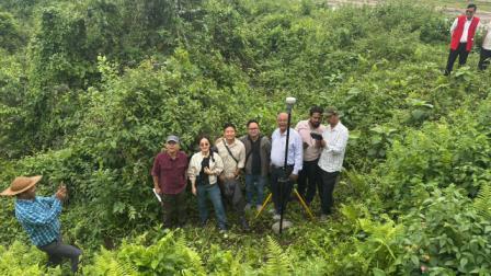
BOMDILA, Jul 2:A days’ training on mobile application and Management of Information system (MIS) under ‘Satellite Based Monitoring & Geo – tagging of Developmental Projects for precision monitoring’ in the district was conducted today at district headquarters Bomdila by the Department of Planning & Investment in collaboration with the State Remote Sensing Application Center (SRSAC) Itanagar.
Observing that as there was no proper collaboration or synchronization between the executing agencies, Deputy Commissioner Dr. Sonal Swaroop said that the Geo-tagging of the various projects under NEC, NLCPR, RIDF, SIDF, BADP, SPA, CRF and MPLADS was a must to ensure transparency and compliance of public accountability. Besides clear review and monitoring of the schemes implemented, this would facilitate proper planning for the new schemes to be implemented whereby chances of duplicity would be totally eliminated, she added.
The trainers from the Department of Planning & Investment and SRSAC imparted hands on training on mobile application and on Management of Information System.
The day before, the team accompanied by the district Planning Unit Geo-tagged various schemes under Dirang block. Schemes at Nafra and Kalaktang blocks would be geo-tagged the day after and the left out schemes would be covered in the second phase.
Among others, HODs and representatives of all the implementing agencies attended the training programme.

Kenter Joya Riba
(Managing Editor)She is a graduate in Science with post graduation in Sociology from University of Pune. She has been in the media industry for nearly a decade. Before turning to print business, she has been associated with radio and television.
Email: kenterjoyaz@easternsentinel.in / editoreasternsentinel@gmail.com
Phone: 0360-2212313