-
36-hr ICR bandh marred by sporadic violence, Sub inspector…
-
Governor condoles demise of Bengia Tolum
-
Arunachal Pradesh to undertake Special Intensive Revision of …
-
Large acreage of wild cannabis destroyed in joint…
-
New community hub 'Ekta Bhawan' opens at Yazali Police…
-
Dr. Joram Aniya calls on Governor
-
Indian Army inaugurates transit facility at Sigar Military Station
-
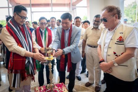 Khandu inaugurates Arunachal Niwas, fourth facility in New Delhi
-
ACS announces sit-in protest, demands CM’s resignation on moral grounds
-
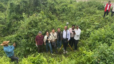 Assam-Arunachal border delineation exercise concludes in Lower Siang
ITANAGAR, Aug 26: Surveyor General of India, Lt General, Girish Kumar has assured to assist and extend all possible technical expertise in the field of Geospatial domain to improve the developmental planning, monitoring and management of natural resources of Arunachal Pradesh.
He assured this to a visiting team of State Remote Sensing Application Centre (SRSAC), Arunachal Pradesh, led by its Director, H Dutta accompanied by Deputy Director, Tana Tage, recently at Dehradun.
Lt General Kumar expressed his keen interest to share Geospatial technology with the State Remote Sensing Application Centre (SRSAC), Arunachal Pradesh for village-level survey using Spatial Data Module Structure (SDMS) developed for Mobile Mapping application, mapping of five major river basins, currently taken up for Brahmaputra basin under National Hydrology project funded by World Bank.
He also expressed his willingness to provide technical expertise for DEM generation with vertical as well as horizontal accuracy for flood modelling geodatabase of 1.2K scale, flood forecasting, observation of water reservoir in real time, creation of Geoidal Model of 10 cm and establishment of Continuously Operating Reference Stations (CORS) network sites in Arunachal Pradesh for government agencies that collect GPS data to improve precision and accuracy of positions, which are useful for supporting three dimensional positioning, meteorology, space weather and geographical applications.
Citing an example of Geospatial Smart Village recently developed by Chinese authority based on Geospatial Technology, Lt General Kumar said that accurate village-level information is not available from ground level to improve infrastructure planning, utility management etc. Therefore, he emphasized to use Geospatial techniques to help the state government to identify villages lacking in basic infrastructure and ensuring their all-round development at the micro level.
On invitation from the State Government, he assured to visit the state sometime in October this year once modalities got completed for collaboration and sharing of Geospatial technologies between the Survey of India and State Remote Sensing Application Centre, Arunachal Pradesh for the signing of MoU.
Sharing working experience on Geospatial technology, SRSAC Director, Dutta said due to diversified topography and varied agro-climatic conditions of the State, it offers vast potential adding that it also provides a challenge in the inventory, mapping and monitoring of diversified resources of the State.
“In that context, advanced state-of-the-art Space technologies like Remote sensing, Geographical Information System (GIS), Photogrammetry, Global Positioning System (GPS), etc can play a significant role,” he stressed.
He further informed that Geospatial Data Sharing under existing National Spatial Data Infrastructure (NSDI), Ministry of Science and Technology, GoI, SRSAC is working on the establishment of a “Central Hub” to maintain RS & GIS inventories information on current and planned GIS application.

Kenter Joya Riba
(Managing Editor)She is a graduate in Science with post graduation in Sociology from University of Pune. She has been in the media industry for nearly a decade. Before turning to print business, she has been associated with radio and television.
Email: kenterjoyaz@easternsentinel.in / editoreasternsentinel@gmail.com
Phone: 0360-2212313