-
36-hr ICR bandh marred by sporadic violence, Sub inspector…
-
Governor condoles demise of Bengia Tolum
-
Arunachal Pradesh to undertake Special Intensive Revision of …
-
Large acreage of wild cannabis destroyed in joint…
-
New community hub 'Ekta Bhawan' opens at Yazali Police…
-
Dr. Joram Aniya calls on Governor
-
Indian Army inaugurates transit facility at Sigar Military Station
-
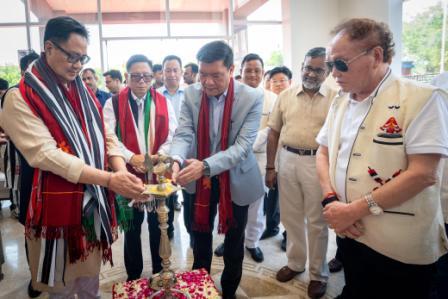 Khandu inaugurates Arunachal Niwas, fourth facility in New Delhi
-
ACS announces sit-in protest, demands CM’s resignation on moral grounds
-
 Assam-Arunachal border delineation exercise concludes in Lower Siang
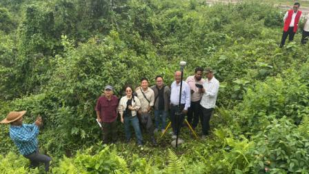
Dirang, Apr 26: A joint team comprising of scientists and engineers undertook detailed glacio-hydrological studies at the Khangri Glacier in the Gori-chen mountain range from April 19 to 26.
The Centre for Earth Sciences and Himalayan Studies (CESHS), Government of Arunachal Pradesh along with the National Centre for Polar and Ocean Research (NCPOR), Goa, Ministry of Earth Sciences and the Indian Institute of Technology Guwahati (IITG), conducted the studies as part of the 3rd high-altitude expedition to the Khangri Glacier in the Gori-chen Mountain region.
The joint team—comprising four scientists and engineers each from NCPOR and CESHS, and one expert from IIT Guwahati—undertook detailed glacio-hydrological studies aimed at understanding the glacier's health and associated water resources. Key activities included glacier mass balance measurements at 5032 msl aimed at understanding the glacier's health and response to climate change.
As a pioneering effort in the region, the team conducted a comprehensive risk assessment of Rani Lake, a Category-B glacial lake—identified by the National Disaster Management Authority (NDMA)—for its potential to trigger Glacial Lake Outburst Floods (GLOFs). This involved a bathymetric survey to determine lake depth and volume, along with terrain observations to evaluate moraine stability, drainage pathways, and downstream hazard potential.
To support continuous climate monitoring, the team also performed maintenance of an Automatic Weather Station (AWS) and successfully retrieved winter-over data, ensuring uninterrupted acquisition of essential meteorological parameters critical for glacier and climate studies.
In addition, the team also performed maintenance of water level sensors and conducted direct measurements of glacier meltwater discharge, enabling accurate assessment of total runoff from the glacier system.
Marking another first-of-its-kind initiative, the team carried out a first-ever Reconnaissance Survey of a cluster of Category-B glacier lakes located at an altitude of 5300 msl. These lakes, identified by the NDMA, were assessed for their risk potential to inform future hazard mitigation and disaster preparedness strategies. Reaching the remote site involved a strenuous high-altitude trek across rugged terrain, snow-covered passes, and rapidly changing weather conditions, indicating the logistical challenges faced by the scientists.
Additionally, in order to make such expeditions more convenient the team successfully identified a suitable site at Mirathang for establishing a long-term high-altitude Field Research Station.

Kenter Joya Riba
(Managing Editor)She is a graduate in Science with post graduation in Sociology from University of Pune. She has been in the media industry for nearly a decade. Before turning to print business, she has been associated with radio and television.
Email: kenterjoyaz@easternsentinel.in / editoreasternsentinel@gmail.com
Phone: 0360-2212313